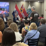
St. Louis Mayor Cara Spencer is presenting the city’s final route plan for a north-south Bus Rapid Transit line to the East-West Gateway Council of Governments this morning, bringing the project one step closer to reality.
Obtaining regional council approval is critical for accessing federal funding, according to Scott Ogilvie, the city’s planning executive. He notes that the Federal Transit Agency is expected to fund approximately half of the project’s costs. Current estimates place the total project cost between $360 million and $590 million.
Get a fresh take on the day’s top news
We will never send spam or annoying emails. Unsubscribe anytime.
City voters approved a new tax in 2017 to fund a third MetroLink line, the Green Line, designed to run north and south. The tax has generated approximately $110 million to date, but building even a basic light rail line would require an estimated $1.1 billion. Consequently, the city shifted its focus to Bus Rapid Transit instead.
“Bus rapid transit is the way of the future,” Spencer states, noting its reduced construction expenses and route adaptability. Bus rapid transit functions as a hybrid between traditional buses and trains. The buses operate in dedicated lanes, stop at elevated stations, and receive priority at traffic lights to improve travel speed.
Spencer will unveil the city’s selected route at today’s East West Gateway Council of Governments meeting. The route begins at its southern terminus near Minnie Wood Park in Dutchtown, at Meramec and South Broadway. It extends north to Jefferson, making stops at Chippewa, Gravois, Arsenal, and Park Avenue, among others. The line then turns east on Chouteau and north on 18th Street before heading downtown on Tucker Boulevard. The northern section travels along Florissant to Jefferson and Natural Bridge, with eight stops distributed along Natural Bridge before concluding at Goodfellow. Following Spencer’s presentation, the regional council will vote on the proposal.
“Ridership will flow from the endpoints into the center and into downtown,” Ogilvie explains.
The chosen route was one of two finalists. The alternative proposal featured significantly fewer downtown stops and routed much of the line along Jefferson rather than Tucker. “I believe that option would have missed an opportunity to connect people more directly to downtown,” Spencer says.
According to Ogilvie, both routes were viable options, but the selected route better reflects existing transportation patterns and is located near more affordable housing, which typically attracts riders. He also notes that the BRT line extends further than the originally proposed light rail and reaches nearly to the county line on its northern end. This positioning may allow the county to develop a complementary project that connects with this one. “Looking ahead, that’s been the region’s primary long-term strategy,” he explains.
Over the next year, Ogilvie indicates the city will refine cost estimates while conducting preliminary engineering work, determining curb relocations, selecting bus types, and designing station features. Should everything proceed without complications, the BRT line could open by 2031.
A remaining issue concerns the $110 million collected through the 2017 tax. Spencer maintains that this funding can be redirected to bus rapid transit without complication. However, some city officials, including Aldermanic President Megan Green, contend that voters should approve the transfer of light rail funds to BRT through an additional vote. A representative for Green indicated that no voting timeline has been established at this time.